Cyclone Narelle strengthens over WA coast

Cyclone Narelle is now larger and ‘more severe’ as it crosses the Western Australian coast
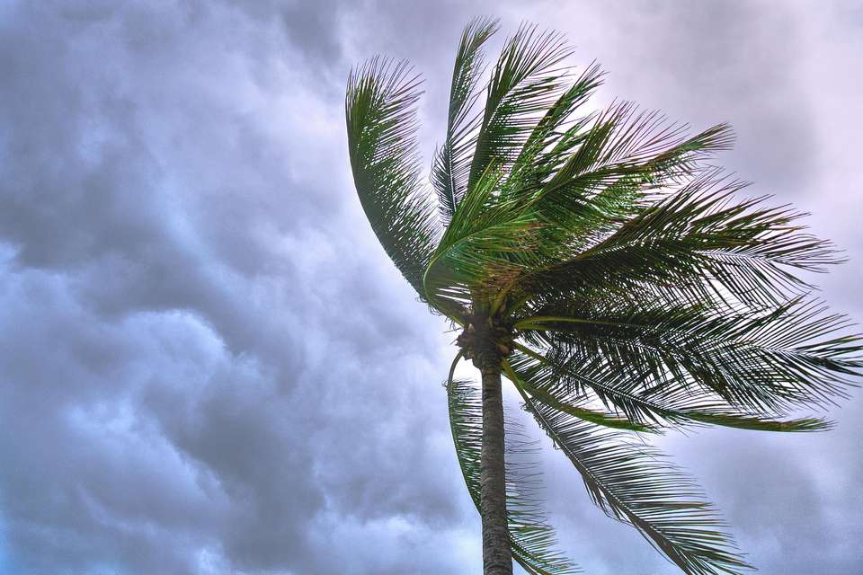
Severe Tropical Cyclone Narelle continues to amaze us with its long journey across northern Australia.
This cyclone began life near the Solomon Islands on March 16, when moist air rose rapidly and created a low-pressure zone. Narelle crossed the Cape York Peninsula last Friday as an intense but compact category 4 system, and continued a steady westerly track across the Gulf of Carpentaria, the Northern Territory and the Kimberley region of Western Australia.
Today the cyclone crossed as a dangerous category 4 cyclone near Exmouth, in the far northwest of WA. So far, Narelle has travelled more than 5,700 kilometres since it formed as a system near the Solomons, according to the Bureau of Meteorology.
It is relatively rare for an individual tropical cyclone to affect Queensland, the NT and WA. The last time was Severe Cyclone Ingrid in 2005 and Cyclone Steve in 2000. The final path of Narelle is likely to be very similar to Steve, with its final dissipation in the Great Australian Bight.
A large and severe cyclone
Narelle is a much more severe cyclone than Steve, however. The system is now twice the size it was when it reached far north Queensland a week ago — as measured by the area of strong gales around its eye. These damaging winds now extend 200–260km from the centre, while destructive storm-force winds extend 110–210km, and the very destructive core of hurricane-force around the eye is 90–130km wide.
The cyclone’s larger core poses a significant threat to settlements in its path from both severe winds and intense rainfall. Dangerous storm surge and ocean inundation is also a high risk for exposed coastal locations along its path. There will be much greater impact if it passes by at or near high tide.
So far, wind and storm surge damage from the cyclone has been minimal, as it has tracked over more sparsely populated areas. Its worst impacts have been heavy rain and flooding across NT catchments, which were already saturated from weeks of monsoonal rain. The west of the continent is unlikely to be so lucky.
An unusually predictable path
Narelle’s track, forward speed and intensity have been remarkably predictable compared with many cyclones in the Australian region. Prevailing easterly winds under the cyclone, associated with a subtropical high pressure ridge over southern Australia, have propelled it along at 15–25km per hour over the past week.
Narelle is now being steered around the northwestern periphery of the same high-pressure system, and this is why its track is now more to the south southwest. It is expected to intensify over warm ocean waters. It will continue to move in a more southerly direction and maintain intensity as a dangerous category 4 cyclone until later today, before weakening to a still severe category 3 system near Shark Bay. The towns of Onslow and Exmouth are expecting severe impacts as the core winds pass over them, with wind gusts of up to 250km per hour. Further south, Carnarvon is expecting winds up to 200km per hour this afternoon.
Weakening over land
The world heritage-listed Ningaloo Reef is likely to be severely affected by the cyclone as its core winds pass along its entire length. This is a double whammy for the reef, after the severe 2025 marine heatwave caused catastrophic coral bleaching and high mortality. Some areas lost up to 60–80% of coral. Coral reefs that are already stressed by coral bleaching are likely to take longer to recover, if they are struck soon after by a powerful tropical cyclone.
Narelle will still be a severe category 3 system when it tracks through Shark Bay, probably on Friday, but will begin to weaken as it moves over land south of the tourist town of Denham. An approaching upper trough from the Southern Ocean will begin to interact with the cyclone and force it to track more quickly to the south-southeast. This will see it weaken to a category 2 as it passes just inland of the major town of Geraldton. Due to forecast changes in wind speed and direction near the cyclone from the west, the strongest winds will shift to its eastern flank and the system will begin to lose its tropical cyclone characteristics.
The people of Kalbarri and Northampton, small towns north of Geraldton, will be on edge as they remember April 2021, when the towns suffered serious damage from category 3 Tropical Cyclone Seroja.
The WA capital Perth is likely to avoid the core of the cyclone as it undergoes extra-tropical transition. This is when a cyclone loses its tropical warm core and becomes more extra-tropical in structure, meaning its strong winds and heavy rain can be expected to spread out from the centre over a wide area of the greater southwest during Saturday.
On the positive side, widespread rainfalls are forecast for most of the WA Wheatbelt. This will be welcomed by farmers as they typically sow their winter wheat crops between late April and June.
Tropical cyclones becoming more intense
It’s too early to draw a link between Cyclone Narelle and background global heating of the oceans and atmosphere, largely driven by rising greenhouse gases from the combustion of fossil fuels. This will require detailed attribution studies, which factor in natural variations in the climate system with those being driven by human-driven climate change.
Numerous studies now confirm globally tropical cyclones are becoming more intense and delivering higher short-term and daily rainfall than in the past. In the Australian region, there has been a decline in overall cyclone frequency in recent decades, but the ones we’re getting now are more intense and producing more rainfall. This trend is expected to continue under future global heating.
This article is republished from The Conversation under a Creative Commons license. Read the original on The Conversation website.

