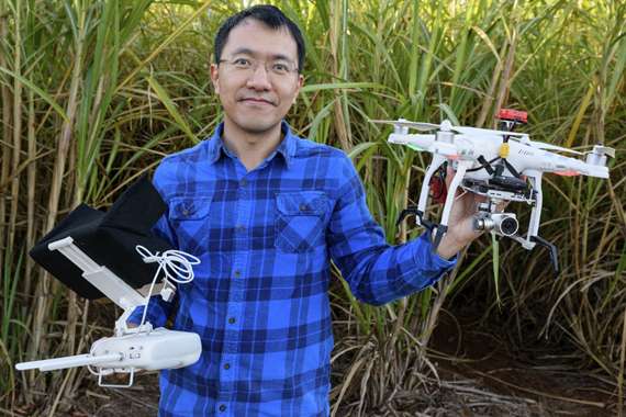
Drone Surveillance a Big Brother for Crop Pests
Description
The use of drones loaded with high-definition, thermal and multi-spectrum cameras as research tools for monitoring crops is increasing across the
horticultural sector. This study seeks to understand the best uses of the technology, and its effectiveness in early detection of pests and disease.
Partners
AustChilli, Queensland Department of Agriculture and Fisheries (various sugarcane researchers) and Peanut Company of Australia
Impact
Working with primary producers to measure the impacts on horticultural management supported by drone monitoring data will allow the growers and the horticulture industry to make informed decisions about large-scale adoption of the new technology.
Dr Chengyuan (Stephen) Xu
When it comes to protecting crops from pests and diseases, rapid detection is a vital element for ensuring a successful response. But across Queensland's large-scale agriculture, primary producers can struggle to cover the hectares required often enough to spot problems as they appear.
A research project at CQUniversity aims to harness drone technology, to ensure monitoring is efficient and economical – while gathering a vast amount of crop and environment information. The drone project is led by Dr Chengyuan (Stephen) Xu, based at CQUniversity Bundaberg campus, and supported by the Institute for Future Farming Systems.
"We know that the sector wants continuous improvement in its management practices and precise manipulation of crop production – so future precision horticultural systems will require on-farm data collection across unprecedented broad spatial and temporal scales," explains Dr Xu.
"As a cutting edge technology, unmanned aviation vehicles (UAV) like drones provide an efficient and economical way to gather a vast amount of crop and environment information, which can be applied across many aspects of horticulture."
Home to 10 per cent of all Queensland's agriculture, Bundaberg and Wide Bay's $1.4 billion agriculture industry makes it one of Australia's largest horticultural regions – and ideal for precision research. In the new trial, six drones loaded with high-definition, thermal and multispectrum cameras (funded by a $43 000 CQUniversity Research Infrastructure Block Grant) are collecting image data to map vegetation density and build 3D structures of crop canopies.
As well as detecting pests and diseases, the information delivers numerous industry applications, including yield prediction, crop nutrient and water status, and ability to develop variable rate fertilisation schemes, and assess irrigation system performance. "All these outputs will support the operation,
management and decision-making of local industries," says Dr Xu.
"And the farmers we're working with are really excited to get that extra confidence, that they're seeing issues in their crops as they emerge, and while there's still time to react and protect their crops."
Dr Xu is a plant ecologist whose broad research and work in plant ecophysiology, invasive plants, and plant-soil interaction has taken him from his homeland of China, to the United States, and eventually to Australia. Previously a postdoctoral research fellow at CSIRO, Dr Xu's been with CQUniversity since 2016, and has also worked closely on protected cropping systems (greenhouses, polytunnels) in the Bundaberg region to
combat crop issues.
Two CQUniversity research higher degree students working on drone applications recently published their papers in the conference proceeding of the 30th International Horticultural Congress, and presented their study at the 2018 event in Istanbul, Turkey.
Connect with CQUniversity
At CQUniversity we know the value of our connections locally and around the world. Our partnerships help us create opportunities, deliver solutions and change lives. From time to time, we share our Connections Count update where we share our highlights, including research impact stories like the ones below. Sign up to become one of our valued connections.

